The geographical data needed for a comprehensive view of the electric distribution system come from several sources within the utility or originate from other organizations.
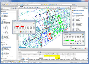
With the CYME Geographic Overlay module, digitized maps can be displayed as layers along with the network model. This allows the power engineer to efficiently prepare planning and maintenance projects that take into account the relevant infrastructure information.
The CYME Geographic Overlay allows the engineer to view geographic information useful to the utility as multiple layers underneath the representation of the distribution network. This includes the network connection information, assets, resources, etc.; but also land register, rights of ways, hydrography, topography, land cover, land use, population density, etc.
The module allows the import and display of several maps of different formats (raster or vector) along with the capability to enable for viewing and disabling any layer or theme. They can be placed in any order, with the CYME distribution system model on top.
The module imports map files as data layers. The formats supported are:
- AutoCAD� .DXF and .DWG maps
- ESRI Shapefiles .SHP
- Google� KML files
The module allows the automatic display of the geographic background whenever the network model is loaded or a study opened.
The module can be used in conjunction with the CYME Online Maps Service to display offline and online maps simultaneously; allowing to the user to locate equipment and devices on the one-line diagram using street addresses, X/Y Coordinates or GPS coordinates.
The functionality of both components is accessed through a comprehensive background map control tab in the CYME software.